Image Page on Costa
Rica
Insert pictures, and at least one panorama image, and a webcam image from two different times.
Outline
- Landscapes
- Surfing in Tamarindo
- Irazu Volcano
- Tapanti National Park
- Playa Cocles
- Cities
- San Jose
- Tamarindo
- Buenos Aires
- Limon
- Landmarks
- Arenal Volcano
- Monteverde Cloud Forest
- Stone Spheres
- Guayabo de Turrielba
- Images of People
- Oscar Arias Sanchez
- Chorotega people
- Robert August
- Costa Rican
wedding
- Images from the book
- Overview map
- “When to go
chart”
1 Landscapes
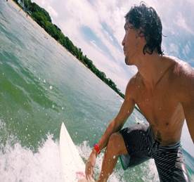
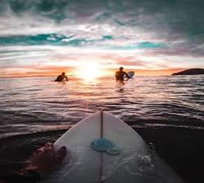
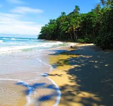
Tamarindo surfing, day
and night. The pictures above highlight the beauty of Tamarindo during the day
and at night, shot on a GoPro. Tamarindo is a surfing community on the North
Pacific coast of Costa Rica. Pico Pequeno, Pico Grande, and River Mouth are the
most famous surf spots. Before some adventurous American surfers found Playa
Tamarindo in the early 1970’s it was mainly a fishing village, by the
mid-1990s emerging as one of the world’s most premier surfing locations.
What makes Playa Tamarindo so unique for surfing conditions is the 3-miles of
U-shaped beach, the frequent low-pressure zones that occur in Northwest Costa
Rica, as well as the estuary that creates continually new lines and levels of
sand on the beach floor.
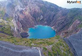
A crater lake at Irazu. The last time Irazu Volcano erupted was in the 1960’s, showering ash on Costa for days afterward. The Irazu National Park bosts 2309 hectares of land from the Cloud Forest to tropical rainforest-upland. The elevation of Irazu Volcano is 11,260ft. The most popular hike is to the Diego de la Haya crater. The name “Irazu” comes from an indigenous word meaning “Thunder and Earthquake Mountain.”
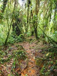
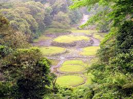
Arboles Caidos. The toughest trail at Tapanti National Park is Arboles Caidos. The hike is 1.5-2 miles of terrain of varying elevation and dense jungle. This is one of the rainiest areas of Costa Rica, receiving 250-300 inches of rain each year. The park is 5,058 hectares (12,500 acres) and provides an environment that supports over 400 species of birds, among many other animals. Hiking, swimming, picnicking, and bird watching are the most popular activities in the park.
Playa Cocles. This is one of the 3 best beaches on Caribbean side of Costa Rica, which also includes Playa Chiquita and Punta Uva. This area is less traveled to than Tamarindo and its western beach counterparts. It has a relaxing vibe with beaches that are equally as beautiful if not more so than beaches on the west coast. Because of the geographic location of these beaches, they are green all year round. When you stay at these beaches, because of the lack of tourists, you can bask all day in the sea, beach, and beautiful trees.
2
Cities
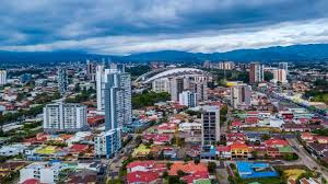
City of San Jose. At an elevation of 3,800ft above sea level, San Jose is Costa Rica’s largest city. It became one of the most important production centers in Costa Rica in the 19th century, based mainly on coffee. San Jose is the most important transportation hub in Costa Rica, with the Pan-American Highway connecting the Atlantic and Pacific coasts. There are 339,581 residents of San Jose.
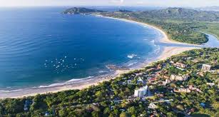
Town of Tamarindo. Surfing is the reason why the city of Tamarindo developed. It is the number 1 sport. Surfing, coffee, exercise, and relaxation are 4 very cultural significant parts of Tamarindo culture. The population of Tamarindo is 6,375.
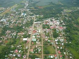
City of Buenos Aires. Buenos Aires is home to the largest indigenous tribes in Costa Rica. The town's proximity to Chirripo National Park, the Hitoy-Cerere Biological Reserve and La Amistad International Park make Buenos Aires an ideal base of operations for adventurous travelers who want to explore the rugged Costa Rican landscape on their way to these national parks. The population of Buenos Aires is 48,706.
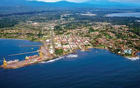
Limon. Limon is the 7th largest city in Costa Rica, with a population of 55,000. Limon is known for having miles and miles of relaxing picturesque coast-line—125 miles to be exact. Limon is one of the most diverse geographical regions in Costa Rica, host to wetlands, mountains, and white beaches.
3
Landmarks
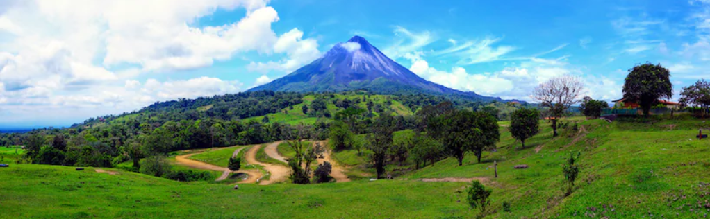
The majesty of Arenal. A panoramic shot of Arenal Volcano, Arenal is the 3rd most conical shaped volcano in the world. It is the second most popular volcano in Costa Rica, after Irazu. When the sun goes down around Arenal, the real beauty comes out, as the volcano’s reflection can be seen in the reflection of the lake surrounding it.
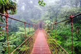
Monteverde Magic. Fairly rare, Cloud Forests represent 1% of global woodlands. Cloud forests typical form between 3,300-9,850ft. Water evaporates of the coasts of Costa Rica, the wind pushes air up into the steeper elevation of the inland rainforests, and then the air suspends, and the water vapor condenses into clouds. At times the Monteverde bridge can be completely consumed by clouds with visibility less than a 10-feet.
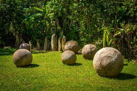
Finca 6 Archaeological Site. The stone spheres are located on the Isla del Cano and the Diquis Delta. Locals believe that the spheres were a product of artisan mastery and a way for local chiefs to display their power. Although much anecdotal history points towards this information being true, no one truly knows how these artisans could possibly create these perfect spheres.
Guayabo de Turrielba. This beautiful site is located on the slopes of the Turrialba Volcano. This archaeological site is thought to be the largest city in the region from 1000BC to 1400AD, before it disappeared. The mystery is that the archaeological and anecdotal evidence of life in this area stop at 1400AD.
4
Images of People

Oscar Arias Sanchez, 2015. One of the most important figures in Costa Rican history, Oscar Arias Sanchez won the Nobel Prize in 1987. He won the Nobel Prize for his role in promoting piece in the region. He brokered a piece deal that set guidelines for a healthy economic and social environment between Costa Rica, Guatemala, El Salvador, Honduras, and Nicaragua.
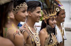
Indigenous celebration. The Chorotega tribe was the most powerful indigenous tribe in Costa Rica around the time of the Spanish conquest. This is a picture of some Chorotega youth at a local celebration.
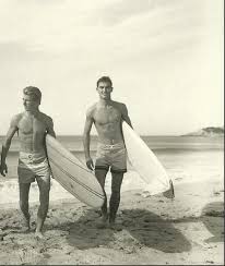
The Endless Summer. Robert August and Bruce Bowen took a trip to find the greatest surf spots around the world, in 1964. Most surfers in America believed that California had the best surf. Bowen and August set out on a journey that captured the hearts and minds of American surfers, inspired a sense of adventure for generations to come, and created the most influential surfing documentary on the planet.
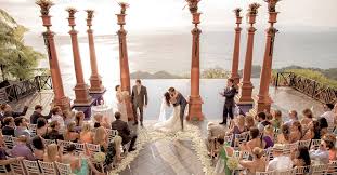
Costa Rican Wedding. It is traditional in Costa Rican weddings for the groom to serenade the bride, for Portals to be offered to the couple, and for a meal to consist of rice, black beans, stewed meat, salad, and some sweet plantains.
5
Images from the Book
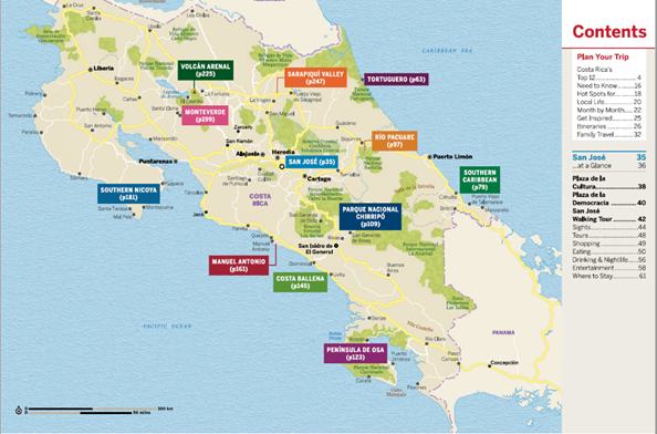
This is an overview map of Costa Rica from Lonely Plant, “Discover Costa Rica.”
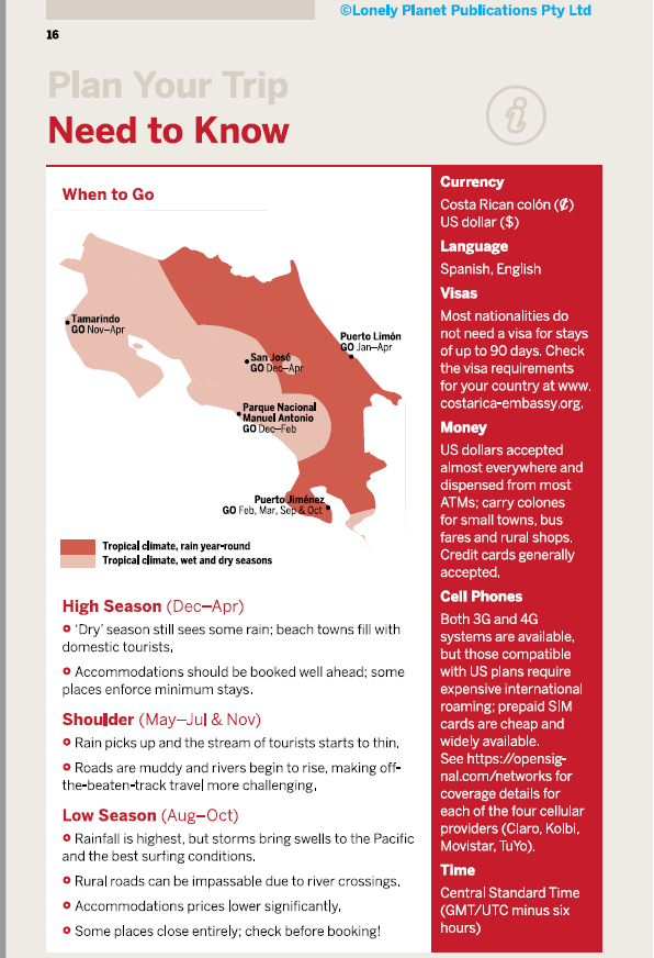
This introductory page gives basic information on weather and “needs to know” about different regions of Costa Rica.
Submitted
by your Tim Callahan on April 5th.